Over the past decade, China has astounded the world by building new islands from scratch in the South China Sea—a process that has transformed formerly submerged reefs into sprawling bases complete with airstrips, ports, and military facilities. This ambitious endeavor, achieved largely through controversial land reclamation efforts involving vast quantities of dredged sand, has reshaped geopolitics in the region and sparked international disputes about sovereignty, environmental destruction, and military expansion. What started as a strategic move to assert regional dominance has evolved into an audacious engineering feat unlike anything the modern world has witnessed.

These artificial islands were not merely constructed; they were engineered with deliberate geopolitical consequences in mind. By dredging up sand from the seafloor and dumping it onto coral reefs, China’s construction teams have added over 3,200 acres to previously uninhabitable parts of the sea. Despite criticism from neighboring countries and environmental groups, the pace and scale of construction revealed a clear intent: to stake claims in one of the world’s busiest maritime regions. Understanding the mechanics, motivations, and global implications of this island-building campaign sheds light on a new era of conflict shaped not by armies, but by dredgers and legal claims over the sea.
Key developments in China’s island-building campaign
| Timeline | Event/Development |
|---|---|
| 2012 | China begins large-scale dredging activities in the South China Sea |
| 2014–2016 | Major land reclamation operations across seven key reefs in the Spratly Islands |
| 2016 | Construction of airstrips, radar systems, and military buildings begins |
| 2018–2020 | Permanent military installations established on major artificial islands |
| 2022–2023 | Continued infrastructural expansion including ports and housing facilities |
Why China built artificial islands
The primary motive behind China’s island-building was to strengthen its territorial claims in the South China Sea—a region believed to hold vast reserves of oil and gas and serves as a critical transit route for global trade. By transforming submerged reefs into solid ground, Beijing aimed to reinforce its “Nine-Dash Line” territorial claim, a demarcation that covers nearly 90% of the South China Sea. It was a bold strategic move, designed to convert maritime features into de facto Chinese territory through physical occupation and infrastructure development.

However, military advantage was another powerful motivator. The new islands provided China with the ability to house air defenses, long-range sensors, and naval bases, extending its reach and surveillance capabilities far beyond its shores. These installations enable quicker military response times, monitor the movement of regional and global navies, and act as powerful deterrents in geopolitical power plays.
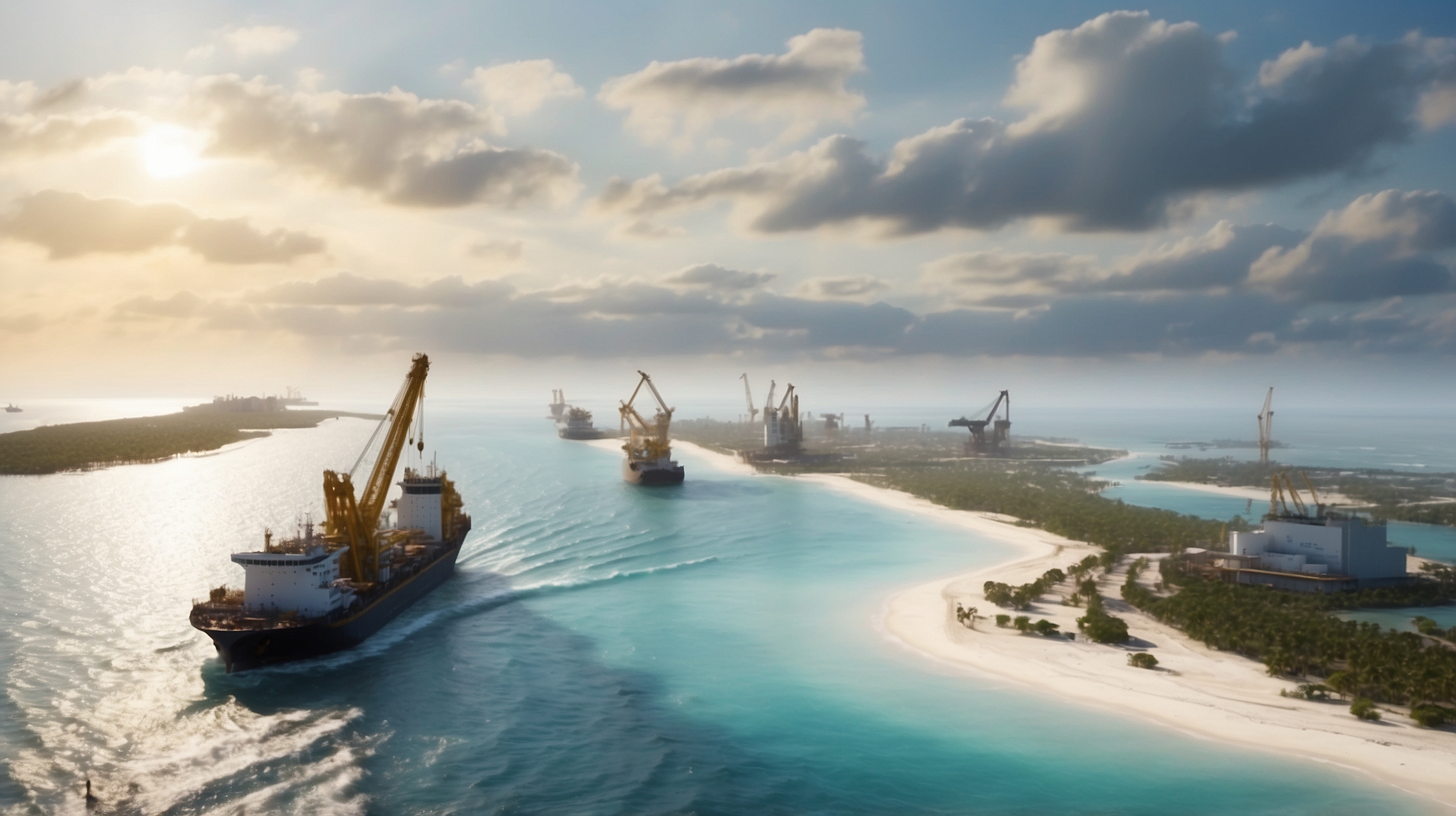
How the islands were built from sand and steel
Engineering new islands in the middle of a vast ocean required one of the largest maritime construction endeavors in human history. The process primarily involved a technique called cutter suction dredging. Gigantic dredgers sliced through the seabed around shallow coastlines and reefs, sucking up sand, crushed coral, and rock, and then spraying or shuttling that material onto the reef tops to build elevation above sea level. Over multiple cycles, enormous amounts of displaced material—estimated in the hundreds of millions of cubic meters—formed the base of new landmasses.

Once the terrain was established, engineers fortified the foundation with concrete, steel, and erosion-control systems before erecting airports, lighthouses, seaports, and military-grade facilities. Aerial runways over 3 kilometers long, anti-aircraft systems, and radar installations soon dotted the transformed landscape. All of this construction occurred rapidly, often in violation of international norms and long before formal diplomatic pushback could curb expansion.
Strategic positioning in the Spratly and Paracel Islands
China’s efforts focused most heavily on the **Spratly Islands**, a contested archipelago claimed variously by Vietnam, the Philippines, Malaysia, and Taiwan. Seven major reefs—Fiery Cross Reef, Subi Reef, Mischief Reef, Gaven Reef, Hughes Reef, Johnson South Reef, and Cuarteron Reef—were transformed with large-scale facilities. In the **Paracel Islands**, China continued expanding and upgrading military infrastructure on Woody Island, an area where it already held control for decades but saw further consolidation after 2015.

Each artificial island in these disputed chains functions as more than just a symbolic statement—they are operational hubs capable of projecting power. Runways can handle military jets and surveillance aircraft while deep ports permit access for China’s navy. Living quarters and bunkers indicate permanent personnel stationed year-round.
Global reaction and maritime disputes
The international community reacted sharply. The United States, Australia, and Japan condemned the actions as destabilizing efforts that violate international maritime law—specifically the United Nations Convention on the Law of the Sea (UNCLOS). In 2016, the Permanent Court of Arbitration ruled in favor of the Philippines in a case asserting Chinese claims were illegitimate based on historical lines. Nonetheless, Beijing rejected the ruling and continued to fortify its positions.

Neighboring states raised concerns over maritime freedom, fishing rights, and ecological damage. Tensions persist as Chinese maritime patrols frequently clash with Philippine and Vietnamese fishing vessels. Western nations have responded with increased naval patrols under the banner of “freedom of navigation operations,” further amplifying military tensions in the region.
Environmental impact of large-scale dredging
One significant cost of this endeavor is environmental degradation. Coral reefs, among the most diverse and delicate ecosystems on the planet, were buried under dredged material. Marine biologists estimate that over 150 square kilometers of reef were permanently destroyed. The silt and debris disrupted marine life patterns, damaged breeding habitats, and reduced fish populations—affecting not only the biodiversity but also the livelihoods of local fishermen who depend on these waters.
Environmental advocates argue that this constitutes an ecological disaster on an international scale. Despite ongoing protests and calls for restoration, experts caution that these submerged ecosystems may take centuries to recover—if at all.
The long-term implications for regional power dynamics
China’s island-building marks a turning point in how power can be asserted in contested waters. Beyond legal declarations or maps, Beijing has effectively changed the geography to support its claims. It’s a form of “territorial manufacturing,” one that converts soft law into hard assets. As a result, the **military and logistical capabilities of China** in Southeast Asia have significantly grown, applying pressure on smaller states and challenging existing security arrangements in the Indo-Pacific.
While no further major land reclamation projects have been initiated recently, China continues to expand infrastructure and maintain heavy military presence on the islands. This signals that the artificial archipelagos serve not just as leverage during negotiations, but as fixtures of China’s long-range strategic vision.
Winners and losers in China’s island creation
| Winners | Why |
|---|---|
| China’s military | Extended range of operations and rapid deployment capabilities |
| Chinese government | Reinforced territorial claims with physical occupation |
| Losers | Why |
| Neighboring Southeast Asian nations | Loss of maritime rights and increased Chinese influence in disputed waters |
| Marine ecosystems | Damaged coral reefs and decreased biodiversity due to dredging |
Expert perspectives on the artificial islands
China’s use of land reclamation uniquely blends engineering with geopolitics—it’s a blueprint for asserting control without direct confrontation.
— Dr. Elena Martinez, Geostrategy Analyst
From an ecological viewpoint, the construction has caused irreversible damage. These are not just islands, but habits lost forever.
— Prof. David Lung, Marine Biologist
This is a modern-day manifestation of power projection. Whoever controls infrastructure, controls access.
— Admiral William Carr, Retired U.S. Navy Commander
Frequently asked questions about China’s artificial islands
How many artificial islands has China built in the South China Sea?
China has constructed artificial infrastructure across at least seven major reef sites in the Spratly Islands, totaling over 3,200 acres of new landmass.
What methods did China use to build these islands?
The primary method was suction dredging, where sediment from the ocean floor was extracted and deposited on coral reefs to elevate them above sea level.
Why is the South China Sea strategically important?
It is a key global shipping route, rich in natural resources like oil and gas, and serves as a crucial military and trade corridor for numerous countries.
What countries claim parts of the South China Sea?
Besides China, countries like Vietnam, the Philippines, Malaysia, Brunei, and Taiwan also lay claim to overlapping parts of the sea.
Has the international community taken any action?
Yes, some rulings like the 2016 Hague tribunal sided against China’s claims, and several countries conduct regular patrols to maintain open sea lanes.
Are the islands permanently manned?
Yes, China has built housing and stationed military and support personnel, demonstrating long-term occupation goals for these artificial islands.
Is there a risk of military conflict over these islands?
While full-scale conflict remains unlikely, the militarization has raised the risk of miscalculations, standoffs, and diplomatic crises in the region.
Can these artificial islands withstand natural disasters?
Despite engineering efforts, experts express concern about vulnerability to typhoons and rising sea levels, which could undermine long-term viability.