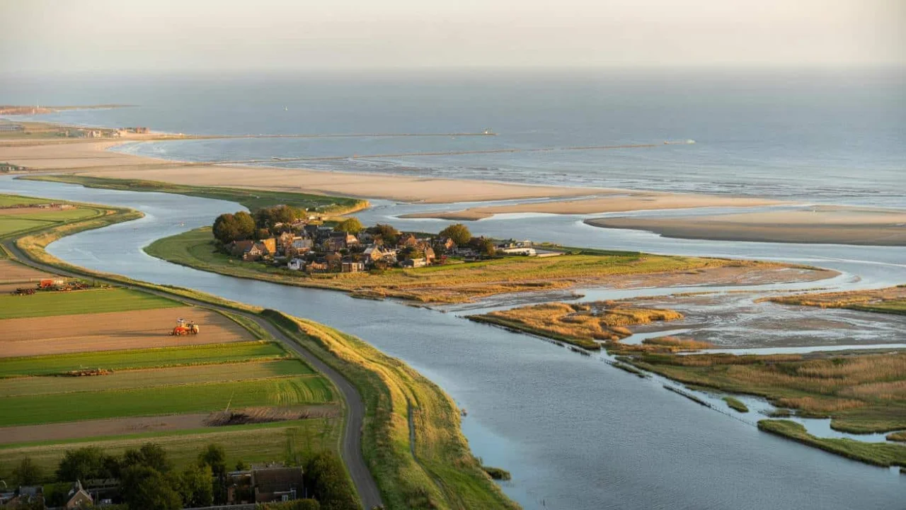
Maria van der Berg still remembers the day she watched bulldozers carve a new river channel just outside her kitchen window. “My grandmother always said the water would take our house someday,” she recalls, standing in what used to be her backyard in Lent village. “Instead, we moved the water.”

That was twelve years ago. Today, where angry floodwater once threatened her home, there’s a peaceful island park where her grandchildren feed ducks. The Waal River still flows past her door, but now it curves gently around a man-made island instead of pressing against the old dike like a caged animal.
Maria’s story isn’t unique. Across the Netherlands, thousands of families have watched their government literally move rivers, reshape coastlines, and create new land from the sea. It’s the latest chapter in a centuries-old battle between the Dutch and the water that surrounds them.

When Fighting Water Becomes Creating Land
Dutch land reclamation has evolved far beyond the famous polders and windmills. Over the past decade, the Netherlands has quietly revolutionized how it manages water by giving rivers room to spread instead of forcing them into concrete channels.
The strategy, called “Room for the River,” sounds deceptively simple. Instead of building higher dikes and stronger barriers, Dutch engineers deliberately flood certain areas during high water periods. They’ve moved entire river channels, created artificial islands, and lowered floodplains across 34 locations along major rivers.

“We realized we were fighting a battle we couldn’t win forever,” explains Dr. Pieter Bloemen, a water management specialist at Deltares research institute. “Climate change means higher river peaks and stronger storms. So we stopped trying to contain the water and started working with it.”
The results have been remarkable. By strategically flooding some areas, the Dutch have actually reclaimed new usable land elsewhere. When rivers have space to spread during floods, they deposit fertile sediment in controlled areas, literally building new ground.
The Numbers Behind the New Netherlands
The scope of these projects is staggering. Here’s what the Netherlands has accomplished through its modern land reclamation efforts:
- 34 major river modification projects completed since 2007
- Over 15,000 hectares of new flood storage areas created
- €2.3 billion invested in river management projects
- Flood risk reduced by 10-fold in key areas
- 3,400 hectares of new recreational and agricultural land gained
| Project Location | Area Affected (hectares) | Completion Year | Primary Benefit |
|---|---|---|---|
| Lent (Nijmegen) | 350 | 2016 | Flood protection + urban park |
| Noordwaard Polder | 4,450 | 2017 | Flood storage + nature reserve |
| Overdiepse Polder | 2,600 | 2014 | Emergency flood relief |
| Munnikenland | 550 | 2019 | River deepening + recreation |
Each project required moving massive amounts of earth and water. The Noordwaard Polder alone involved excavating 30 million cubic meters of soil and relocating 23 farms to create Europe’s largest tidal wetland.
“What we’re seeing is controlled land creation,” notes Jan Broerse, a hydraulic engineer who worked on five major projects. “We lose some agricultural land to flooding, but we gain new coastal areas and better flood protection for millions of people.”
The coastal reshaping extends beyond rivers. Near Marker Wadden, engineers have built five artificial islands using sediment dredged from lake bottoms. These islands now provide habitat for rare birds while protecting the mainland from storm surges.
Living With Water Instead of Against It
The impact on daily life has been profound. Families like the van der Bergs have traded flood anxiety for waterfront property values. Former farmland has become popular cycling routes and bird-watching destinations.
In Nijmegen, the Waal’s new side channel created Veur-Lent island, now home to 12,000 residents in a planned community that didn’t exist fifteen years ago. Streets that would have been underwater during major floods are now lined with cafes and shops.
“My kids learn to swim in water that used to threaten our ancestors,” says Thomas Janssen, a Lent resident whose family has lived in the area for four generations. “It’s the same river, but completely different.”
The economic benefits extend beyond tourism and real estate. Improved flood protection has attracted new businesses to previously risky areas. The Port of Rotterdam has expanded into zones that were considered too vulnerable just two decades ago.
However, not everyone celebrates these changes. Some farming communities have lost ancestral land to controlled flooding areas. “Three generations of my family worked this soil,” explains former farmer Henk Vermeer, whose land was purchased by the government for the Overdiepse Polder project. “The compensation was fair, but you can’t replace history.”
Environmental scientists praise the ecological benefits. The new wetlands and floodplains have become crucial habitat for migrating birds and spawning fish. Water quality has improved as natural systems filter runoff that once flowed directly to the sea.
“We’ve essentially given the rivers back their natural flood patterns, but in a controlled way,” explains Dr. Marieke Storm, an environmental scientist at Wageningen University. “It’s artificial naturalness, if that makes sense.”
Looking ahead, the Netherlands plans to apply these lessons to rising sea levels. New coastal projects will use similar principles: strategic retreat in some areas to create better defenses elsewhere. The Afsluitdijk barrier is being redesigned to become a freshwater reservoir while maintaining storm protection.
FAQs
How much land has the Netherlands reclaimed through these river projects?
The Netherlands has created approximately 3,400 hectares of new usable land while improving flood protection for existing areas.
Do these projects actually move entire rivers?
Yes, several projects have literally relocated river channels, created new side channels, or split single rivers into multiple waterways.
How much did these land reclamation projects cost?
The total investment in Room for the River projects has exceeded €2.3 billion since 2007, funded jointly by national and local governments.
What happens to people whose land gets flooded for these projects?
The government provides fair compensation and relocation assistance. Some former farmland becomes recreational areas or nature reserves.
Are other countries copying these Dutch techniques?
Yes, flood-prone nations including Germany, Belgium, and parts of the United States are adapting similar “living with water” strategies.
How do these projects help with climate change?
By creating natural flood storage and improving river flow, these projects help manage the increased rainfall and storm intensity expected from climate change.