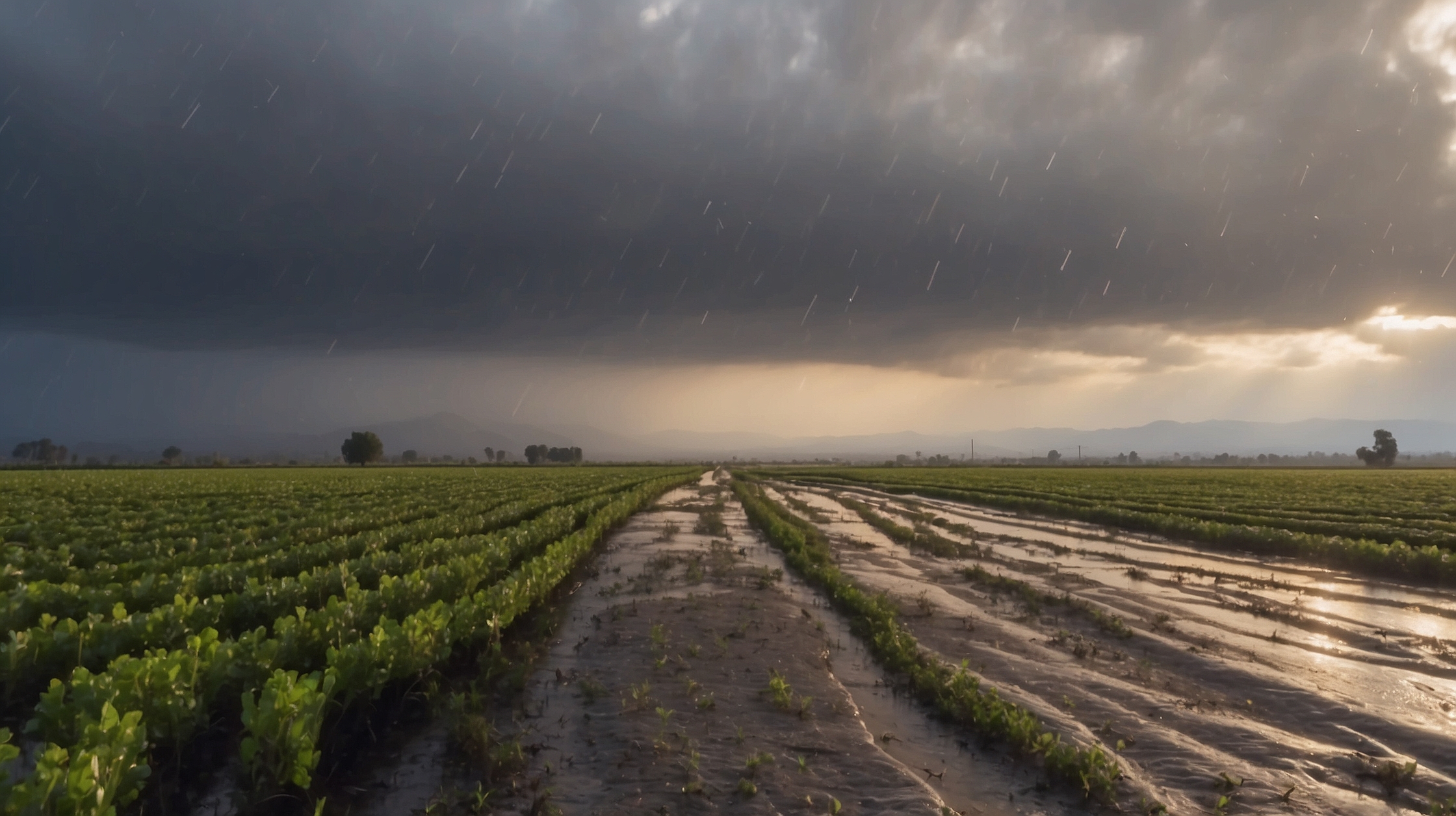
The Golden State is once again under siege from the forces of nature as another atmospheric river barrels toward California. A familiar but feared weather phenomenon, the atmospheric river is poised to bring a heavy onslaught of rain, wind, and potential flooding to regions already saturated from the last storm. Particularly vulnerable is the Central Valley, which could see inches of rain, rising rivers, and renewed emergency concerns. As meteorologists watch the skies, local governments are urging residents to prepare for disruptions later this week.

This latest storm is part of a series of weather systems that highlight a growing trend of extreme weather fueled by climate variability. While the rain brings much-needed water to a state long plagued by drought, its rapid arrival and associated winds could pose significant risks. Flood watches, warnings, and advisories are already being prepared as the Central Valley braces for what could be another record-breaking deluge. The timing, magnitude, and regional impact depend heavily on evolving wind patterns and terrain interactions—but the consensus is clear: communities should take this storm very seriously.
Storm overview and schedule for Central California
| Event | Details |
|---|---|
| Type | Atmospheric River (Category 3-4) |
| Primary Impact Area | Central Valley, including Sacramento, Fresno, and surrounding regions |
| Expected Arrival | Thursday Evening into Friday Morning |
| Rainfall Totals | 2–4 inches in valley areas, up to 7 inches in foothills |
| Wind Speeds | 40–60 mph gusts |
| Flood Risk | Elevated—Flash flooding in low-lying areas, rivers likely to swell |
| Duration | Approx. 36–48 hours of sustained rainfall |
What is an atmospheric river and why does it matter?
An atmospheric river is a concentrated band of moisture streaming through the sky, often hundreds of miles wide and thousands of miles long. Think of it as a river in the atmosphere, carrying moisture from the tropical Pacific straight into the U.S. West Coast. These storms are capable of releasing an immense amount of precipitation in a short period—which has increasingly become the norm during California’s wet season.

When these systems make landfall, they can drop exceptional rainfall rates, often overwhelming infrastructure. In a state like California, where seasonal rainfall can come in spurts, the extremes of having too much water at once—or not enough—create whiplash conditions that are difficult to manage. In recent years, atmospheric rivers have caused flood-related damages exceeding $1 billion annually.
“Atmospheric rivers are moisture bombs from the tropics. We’re not just getting wet—we’re getting hit with a firehose of Pacific moisture.”
— Dr. Lisa Monroe, Climate ScientistAlso Read EM&E Group y GMV revelan acuerdo secreto para desarrollar obuses ATP y SILAM que cambiará la defensa española
Recent damage and preparedness efforts
The previous system that hit the West Coast earlier this month left large swaths of land inundated and caused mudslides in hilly regions. While some communities have barely had time to recover, emergency crews are deploying again in anticipation of similar or worse effects. Power companies are also warning of potential outages as strong winds may down trees and transmission lines.

In counties including Yolo, Stanislaus, Merced, Madera, and Tulare, sandbag distributions and evacuation planning are already underway. Particular concern surrounds the Sierra foothills and mountain communities, where snow-melt could intensify runoff. Urban areas like Sacramento and Stockton are also watching storm drains and levies carefully, given their proximity to major waterways like the American and San Joaquin rivers.
Timing: When rain will hit the hardest
Forecasters currently expect the beginning of widespread rainfall by late Thursday evening, intensifying overnight and continuing through most of Friday. The heaviest rainfall is scheduled for the early morning to midday on Friday, with possible localized rainfall rates of half to three-quarters of an inch per hour.

Peak impact timeframe for Central Valley areas, including major cities like Fresno, Modesto, and Bakersfield, is forecast between 3 a.m. and 3 p.m. Friday. Higher elevation zones such as the Sierras may experience more prolonged precipitation with snow levels rising to over 7,000 feet, reducing snow accumulation but increasing flood potential.
Flood risks and vulnerable zones
The Central Valley is one of the most fertile and flat regions in the world, but this topography makes it particularly vulnerable to flooding. Soil saturation is already high due to previous storms, increasing the likelihood of rapid runoff. Areas with poor drainage systems or limited levee protection are at heightened risk.
Localized flood-prone sectors include:
- Urban areas along the American and Sacramento Rivers
- Rural farmland near the San Joaquin Valley
- Hilly terrain in Calaveras and Amador counties (risk of mudslides)
People living in mobile homes or homes near creeks, channels, or underdeveloped flood plains are being urged to prepare now. The National Weather Service may issue evacuation notices with short notice once flooding begins.
Infrastructure and power grid outlook
With wind gusts expected to top 60 mph in some areas, utility companies and maintenance crews are bracing for power outages. PG&E and other regional providers have begun staging response teams in Sacramento, Fresno, and Bakersfield to quickly restore service should external lines be damaged. Road crews are also on standby to clear fallen trees and debris from main arterials and rural byways.
“We have ground crews pre-deployed across the Valley and foothills to reduce restoration times. Safety is our top concern.”
— Paul Ramirez, Regional Operations Manager
State transportation agencies are also warning of potential road closures and travel difficulties, especially in mountainous corridors like I-80 and Highway 50. Drivers are urged to avoid unnecessary travel during the storm’s peak and to monitor Caltrans advisories for real-time updates.
Who is at greatest risk and how to prepare
People living in flood-prone areas, especially those in old levee zones or near rivers, are at the greatest risk. Communities in south Sacramento County, low basins in Modesto, and agricultural lands near Los Banos are advised to monitor local announcements and prepare for potential evacuation or isolation due to flooded roads.
Residents should:
- Check and clear gutters, drains, and culverts
- Stock up on food, water, medicine, and flashlights
- Prepare sandbags if located in flood-prone zones
- Have a family emergency and evacuation plan
“We’ve seen how fast water can rise in these flash events. Taking 15 minutes to prep now could save your life.”
— Marsha Glenn, Emergency Response Coordinator
Winners and losers from the impending storm
| Winners | Losers |
|---|---|
| Reservoir and groundwater levels | Urban dwellers in low-lying zones |
| Snowpack in high Sierra areas | Farmers with open-air irrigation pits |
| Long-term drought mitigation | Outdoor events and travel plans |
Short FAQs on this week’s California atmospheric river
When will the atmospheric river reach the Central Valley?
Rain will begin late Thursday evening, with the heaviest rainfall expected early to midday Friday.
How much rain can be expected?
Valley areas may receive 2–4 inches, while the foothills and Sierras could get up to 7 inches.
Will this storm lead to flooding?
Yes, the risk is elevated. Flash flooding is possible, especially in low-lying areas and flood plain regions.
Is this storm part of climate change trends?
Experts believe that intensified atmospheric rivers are a sign of warming ocean temperatures and shifting climate patterns.
What should I do to prepare?
Secure outdoor objects, clean storm drains, stock emergency supplies, and prepare for possible power outages.
Will schools or offices close?
Nothing confirmed yet, but some closures may be announced if conditions worsen. Stay tuned to local alerts.
Is travel safe during this weather?
Non-essential travel is discouraged during the storm’s peak on Friday. Mountain routes could be especially dangerous.
Will this help California’s drought situation?
Short-term yes; long-term drought outlook requires many such storms through the season to fully recover groundwater.