
Britain could soon be gripped by a sharp freeze and increased snow risk as meteorologists warn of a **disrupted polar vortex**—a powerful weather event that can trigger plummeting temperatures across Europe. The UK’s recent period of mild winter conditions may be replaced by a severe cold snap, potentially beginning in late January or early February, with the possibility of widespread snowfall.

The polar vortex, a swirling mass of cold air high above the Arctic, has shown signs of weakening and displacement—factors known to drastically alter jet stream patterns. When this system destabilises, it can push frigid Arctic air further south, often resulting in colder-than-average winter months for northern Europe, including the UK.
Experts are monitoring these atmospheric shifts closely, noting strong similarities to past events that ushered in some of Britain’s harshest winters. The key concern lies in what’s termed a **Sudden Stratospheric Warming** (SSW), which causes rapid warming of the upper atmosphere near the pole and leads the polar vortex to split or dislocate, steering cold air toward mid-latitude regions.

UK polar vortex forecast at a glance
| Event | Details |
|---|---|
| Polar Vortex Status | Dislocated and weakening |
| Sudden Stratospheric Warming (SSW) | Possible in late January |
| Expected Impact | Increased likelihood of sharp freeze, snowfall, arctic air incursions |
| Regions Most Affected | Northern England, Scotland, Midlands, potentially southern UK |
| Historical Parallels | 2018 “Beast from the East”, 2010 freeze, 2009 Ice Blast |
| Forecast Accuracy Window | 7–14 days in advance |
Why this winter could feel colder than the rest
While temperatures across the UK have remained relatively mild so far this season, leading forecasters caution that this calm could be the calm before the storm. A **weakened polar vortex** increases the chance of Arctic and Siberian air spilling into Britain, with high pressure building over Scandinavia—a classic setup for cold easterly winds that can bring significant snowfall.
The dislocation of the polar vortex doesn’t always guarantee a freeze, but historically, similar events have resulted in prolonged cold spells. Notably, the infamous 2018 “Beast from the East” event was triggered by a similar breakdown in the vortex, bringing days of heavy snowfall and sub-zero temperatures across the country.

How the polar vortex works and why it matters
The **polar vortex** is a large-scale upper-atmosphere circulation pattern that helps contain extremely cold air close to the polar regions. However, when conditions in the stratosphere change—such as sudden warming above the North Pole—the vortex can weaken or split into smaller vortices that drift southward. This has a direct influence on the strength and position of the jet stream below, which in turn determines UK weather patterns.
In winter, these disruptions are particularly significant. A split in the polar vortex makes cold outbreaks across Europe more likely. According to the Met Office, the chance of a major Sudden Stratospheric Warming tends to increase between January and February, meaning that the upcoming few weeks are critical in determining what kind of winter the UK will experience in 2024.

“If the polar vortex weakens further, we could see blocked conditions develop across northern Europe. That’s when Arctic air can flood in from the east, bringing snow and a significant cold spell.”
— Dr. Andrea Miles, Meteorologist
Past events offer a chilling comparison
Looking back through previous years, several UK winters serve as stark reminders of the polar vortex’s power. In 2018, a major SSW led to the infamous “Beast from the East”, bringing gridlock to roads, flight cancellations, and record low temperatures. Schools closed, and emergency services were under strain.
In 2010, a similar setup caused widespread disruption as snow blanketed much of the country in early December and again in the New Year. The wintry outbreak of 2009 also shares many traits with current meteorological models: a weakened vortex, high pressure in northern Europe, and biting easterly winds funnelled into the UK.
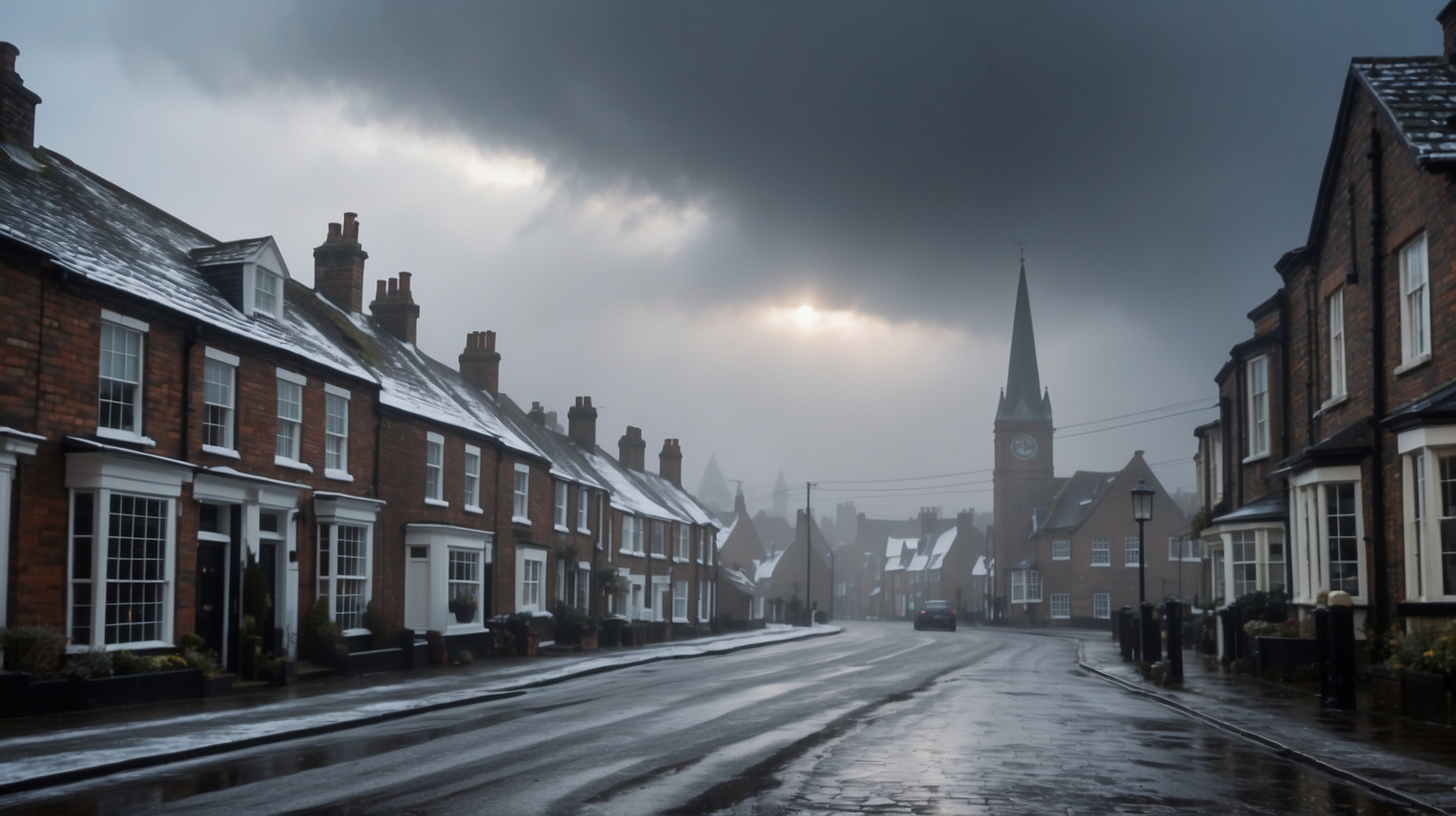
Where snow and sub-zero temps could hit first
Forecast models suggest that **northern England, the Midlands, Scotland**, and even parts of Wales are the most likely to experience early signs of snow and frost if the polar vortex continues on its current path. Coastal areas along the North Sea may also be vulnerable due to strong easterly winds that enhance lake-effect style snow bands.
Urban centres like Manchester, Leeds, and Birmingham could see increasing likelihood of disruptive snow and hazardous driving conditions, especially during rush hours. More severe accumulations might be expected in rural and upland areas.
Projected temperature drops and wind chills
If SSW conditions take hold, **overnight lows could plunge** below -5°C in some areas, with wind chills making it feel closer to -10°C or beyond. Daytime highs may struggle to rise above freezing, particularly in regions exposed to persistent cloud cover and easterly breezes.
While short-lived frosts are common in the UK each winter, a fragmented polar vortex can unlock persistent cold spells lasting a week or more. Energy demand for heating would rise dramatically, putting pressure on infrastructure and potentially straining energy supplies and pricing models.
Winners and losers if the cold hits
| Winners | Losers |
|---|---|
| Winter tourism operators, ski centres in Scotland | Commuters, road hauliers |
| Retailers selling winter gear | Farmers facing crop damage |
| Utility firms with strong cold-weather contingency | Vulnerable households without proper heating |
| Weather app developers and tech tracking cold patterns | Event organisers facing postponements |
Advice from experts on staying prepared
With snow and freezing temperatures potentially on the horizon, both authorities and weather experts are urging the public to stay informed and take early precautions. Keeping an eye on local forecasts will be crucial in the coming weeks, particularly as cold alerts and snow warnings may come with short notice.
“The energy of the atmosphere is shifting. If you’re in the UK, now is the time to ensure you have cold weather essentials at hand—winter tyres, adequate heating and warm clothing should not be left until it’s too late.”
— Peter Rowle, Severe Weather Advisor
In addition to personal preparation, regional councils are monitoring gritting plans and emergency protocols for transport, while healthcare services are preparing for cold-related cases like slips, respiratory issues and hypothermia, particularly among the elderly and vulnerable.
Will the polar vortex always cause cold in the UK?
Not necessarily. Although weakened or displaced polar vortex events increase the risk of cold snaps, the exact outcome depends on a combination of factors like Atlantic pressure systems, jet stream orientation, and local topography. Sometimes, the cold air is shunted toward Europe or the United States instead of the UK.
Frequently asked questions about the polar vortex and UK weather
What is the polar vortex?
The polar vortex is a fast-moving air flow circling the Arctic high in the stratosphere, containing extremely cold air. When stable, it keeps cold air locked around the pole. When it weakens, cold air can spill southward.
What is Sudden Stratospheric Warming?
SSW refers to a rapid temperature increase in the stratosphere above the North Pole, typically over a few days. This phenomenon can cause the polar vortex to split or shift location, often triggering severe cold spells in mid-latitude areas like the UK.
When could the cold spell start?
Forecasters suggest the potential cold spell could begin in late January or early February, though exact timing can vary based on the development of upper-atmosphere conditions.
Will every part of the UK experience snow?
Not necessarily. Snowfall probability is higher in northern and eastern regions, but if the cold pattern becomes entrenched, southern areas like London and the South West could also see snow.
Is this related to climate change?
While polar vortex disruptions are natural, some studies suggest climate change may increase their frequency by modifying Arctic warming patterns and changing jet stream behaviour. But direct attribution remains debated among scientists.
How long could the cold weather last?
Past polar vortex events have led to cold spells lasting 1–3 weeks, depending on how long the upper-air blockage remains in place and whether milder air pushes back later in the month.
Is this similar to the Beast from the East?
Yes. The setup of a weakened polar vortex and possible SSW shares characteristics with the 2018 event, which brought historic snowfall and transport disruption across the UK.
Should I take any action now?
Check home heating systems, ensure cars are winter-ready, and prepare emergency kits with torches, blankets, and non-perishable food. Also, monitor regular weather forecasts for updates.