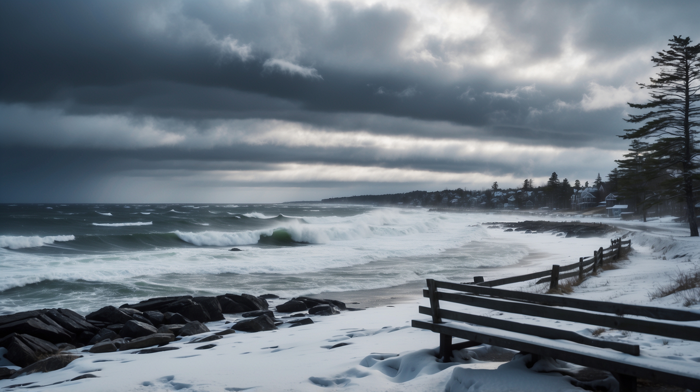

A powerful Nor’easter has barreled its way across the United States this week, unleashing a brutal mix of snow, wind, rain, and coastal flooding in several regions. The winter storm, which began forming earlier in the week, quickly intensified as it moved northeastward, triggering blizzard warnings, school closures, canceled flights, and travel advisories from the Mid-Atlantic through New England. The storm’s impact is widespread, but some areas are expected to endure the brunt of its wrath more than others.

Meteorologists have described this system as one of the most intense Nor’easters of the season, featuring wind gusts that exceed 60 mph in certain coastal regions, along with snow totals forecasted to climb above 18 inches in the hardest-hit areas. For millions of Americans, this means hunkering down and preparing for dangerously reduced visibility, downed trees and powerlines, and difficult road conditions that could last several days. Emergency management officials have urged caution, preparedness, and in many cases, staying off the roads unless absolutely necessary.
Overview of Nor’easter Winter Storm Impact
| Storm Type | Nor’easter |
| Date of Onset | February 25, 2024 |
| Most Affected Areas | New York, Massachusetts, Pennsylvania, New Jersey, Connecticut, Rhode Island |
| Snowfall Forecast Range | 6 to 24 inches |
| Wind Speeds | 40-65 mph, higher along the coast |
| Major Hazards | Heavy snow, strong winds, coastal flooding, power outages |
| Emergency Declarations | Several states under State of Emergency |
Which regions are bracing for the worst conditions
The Nor’easter’s path affects much of the eastern U.S., but the heart of the storm—where meteorologists expect significant accumulation and disruption—runs through the Northeast corridor. New England states are forecasted to receive the heaviest snowfall, particularly parts of central and western Massachusetts, northern Connecticut, and southern Vermont and New Hampshire. These regions may see snowfall exceeding 18 inches, paired with strong wind gusts that reduce visibility and heighten chances of blizzard-like conditions.

Urban hubs such as New York City and Boston are likely to see significant impacts, especially with heavy snow during peak commuting hours. Though these cities might register slightly lower accumulations than interior regions, the combination of ice, sleet, wind, and dense city infrastructure makes impact management more complex. The I-95 corridor remains a key focus due to its importance for travel and commerce, and disruptions here could reverberate economically and logistically for days.
Storm intensity at different elevations and terrain
This Nor’easter’s snowfall intensity does not affect all places equally. Higher elevations in the Poconos, Berkshires, and Catskills are expected to see greater snowfall thanks to orographic lifting, where moist air rises and cools over mountain ranges, intensifying precipitation. Cooler temperatures at altitude also support more snow versus rain, resulting in higher localized snow totals.

In contrast, coastal areas such as Providence, Rhode Island, and coastal New Jersey are toggling between heavy rain and snow due to slightly warmer ocean temperatures, leading to slushy roadways and icy conditions rather than deep snowpack. However, these regions may still be hit hard by coastal storm surges and flooding, particularly during high tide cycles.
Public transportation and flight disruptions
Travel has taken a direct hit from this Nor’easter. Airlines have canceled hundreds of flights out of major northeastern airports including JFK, LaGuardia, Logan, and Newark. Train services along the Northeast corridor, particularly those provided by regional and commuter rail lines, have also reported delays or complete suspensions in service due to snow accumulation on tracks and visibility concerns.

Public buses have suspended routes in cities like Philadelphia and Baltimore, while subways and metros in New York and Washington D.C. are facing partial closures and delays. Departments of Transportation across several states have issued advisories, cautioning residents to avoid travel unless essential, and urging commuters to plan ahead for prolonged delays.
Power outages and emergency responses underway
Strong wind gusts—topping 60 mph in some locales—and heavy, wet snow have caused widespread power outages across several states. Utility companies have mobilized crews for fast-track restoration efforts, but fallen trees and dangerous driving conditions are hampering progress. At the peak, over 500,000 customers were reported to be without power from Pennsylvania to Maine.
State governments have declared states of emergency to unlock funding and activate National Guard units for assistance with plowing, rescue, and debris clearing. Shelters have been opened in various counties to serve those affected by outages or flooding. Officials continue to monitor river and tidal levels closely to prevent overwhelming local drainage systems.
We’ve seen this storm evolve rapidly, with sustained intensity across multiple states. The key message is: stay off the roads and stay informed.
— Sarah Kienzle, Lead Meteorologist, National Weather Service
Schools, businesses, and community impact
Thousands of schools and universities closed preemptively, urging staff and students to stay safe at home. Remote instruction has taken place in some districts, but connectivity issues due to outages have created an additional layer of disruption. Likewise, many businesses have shifted to work-from-home mode, although manufacturing and service industries without that capability have had to shut doors for the storm’s duration.
Local governments and community organizations have stepped up with warming centers, volunteer snow shoveling crews, and emergency supply distribution. For vulnerable populations such as the elderly and unhoused, outreach efforts are in full swing to ensure safety and shelter.
Winners and losers from the Nor’easter
| Winners | Losers |
|---|---|
| Ski resorts benefiting from fresh powder | Air travelers facing cancellations & delays |
| Students enjoying snow days | Utility companies under repair pressure |
| Snow plow contractors in high demand | Small businesses losing day-to-day revenue |
| Weather channels with increased viewership | First responders stretched thin across regions |
How this Nor’easter compares to historic storms
This latest Nor’easter does not quite match up to historic behemoths like the Blizzard of 1996 or 2015’s “Snowmageddon” in terms of total snowfall, but its wide-reaching impact, rapid intensification, and wind strength are drawing comparisons. Storm surge and coastal flooding levels in some towns are approaching records, especially where inland rivers converge with tidal zones.
Climatologists note that while Nor’easters are a frequent winter occurrence, warmer ocean temperatures and higher atmospheric moisture loads — both linked to climate change — can now result in stronger, more precipitation-heavy systems. These storms often form suddenly and can be less predictable in terms of where the rain-snow line will set up, making response planning more complex.
Storms like this highlight how quickly our weather threats can escalate in today’s climate regime. More moisture equals more snow and more problems.
— Dr. Leah Romero, Climatologist, Eastern Institute of Meteorology
FAQs about the Nor’easter Winter Storm
How long will the storm last?
The storm is expected to taper off by the evening of February 27, though residual impacts such as snow-covered roads and downed powerlines may last an additional 24–48 hours.
How much snow is expected in New York City?
New York City could see between 6 and 10 inches of snow, with higher totals inland, depending on temperature and moisture bands.
Is this storm classified as a blizzard?
While not every area is under an official blizzard warning, several regions—including inland Massachusetts and parts of the Hudson Valley—are experiencing conditions comparable to a blizzard.
Are power outages expected to last long?
Due to high winds and icy conditions, some outages may last multiple days, though utility crews are working around the clock to restore service.
Which highways are most impacted?
Interstates I-95, I-84, and I-90 have reported multiple closures and accidents due to slick conditions and low visibility.
What should residents do to stay safe?
Stay indoors, avoid travel, stock up on essentials, monitor local alerts, and ensure that devices are charged in case of a power outage.
Will coastal towns face flooding?
Yes, especially at high tide. Several towns in New Jersey and eastern Massachusetts have already issued flood watches and warnings.
Are COVID protocols affecting emergency response?
While agencies are prepared, some emergency centers are operating with reduced staff or modified protocols due to lingering illness and facility requirements.