Captain Nguyen still remembers the day he couldn’t find his grandfather’s favorite fishing spot. For three generations, his family had anchored near a small coral outcrop in the South China Sea, waiting out storms and pulling in nets heavy with fish. But when he returned last spring, the familiar reef was gone—buried under tons of concrete and crowned with a radar tower that blinked ominously against the dawn sky.
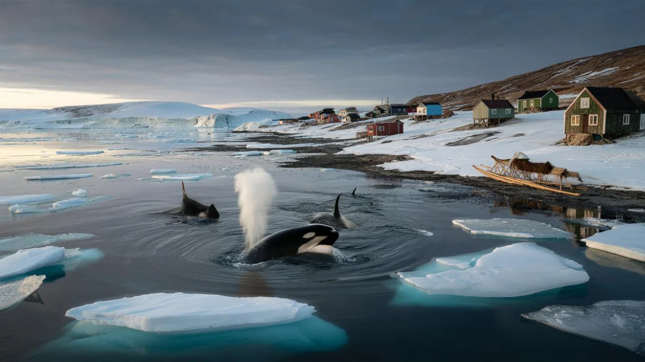
“My grandfather taught me to read these waters by the shape of the reefs,” Nguyen said, staring at what locals now call an artificial island. “Now I don’t recognize my own sea.”
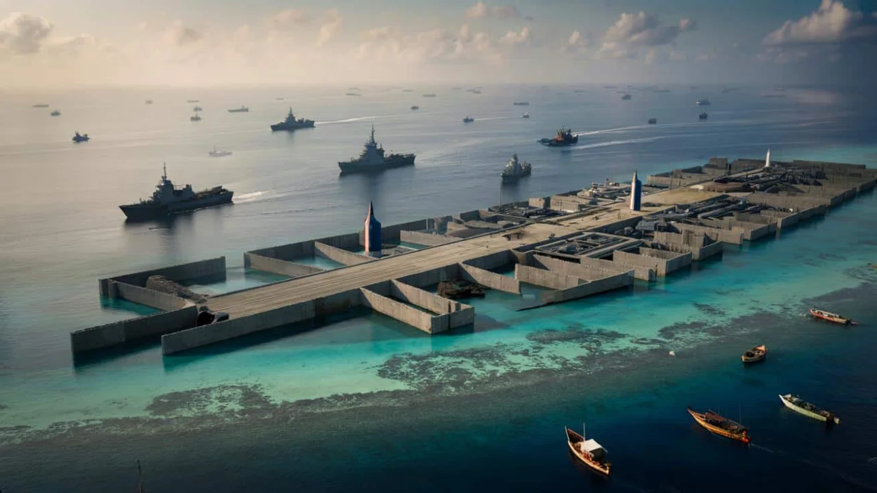
His story isn’t unique. Across the disputed waters of the South China Sea, China has transformed underwater reefs into military strongholds through one of the most ambitious engineering projects of the 21st century. The Spratly Islands militarization has fundamentally altered both the geography and geopolitics of one of the world’s most important shipping lanes.
How Sand and Concrete Rewrote the Map
The transformation began quietly around 2013. China deployed massive dredging ships to remote reefs, sucking sand from the ocean floor and depositing it onto coral formations that barely peeked above high tide. What started as environmental destruction soon revealed itself as military strategy.
By 2016, China had created over 3,200 acres of artificial land across seven reefs in the Spratly Islands. These weren’t just enlarged beaches—they were purpose-built military installations designed to project Chinese power across the South China Sea.

“This isn’t land reclamation in any traditional sense,” explains Dr. Sarah Chen, a maritime security analyst. “This is the creation of unsinkable aircraft carriers positioned at the crossroads of global trade.”
The scale of the operation was staggering. Satellite images show fleets of dredging vessels working around the clock, transforming features like Fiery Cross Reef, Subi Reef, and Mischief Reef from natural formations into geometric platforms bristling with infrastructure.
The Military Hardware Taking Shape
Each artificial island now functions as a forward military base, complete with facilities that would be impressive on mainland territory. The installations include:
- Airstrips: Three islands feature runways over 3,000 meters long, capable of handling military aircraft including bombers and fighter jets
- Radar systems: Advanced surveillance equipment providing 360-degree monitoring of air and sea traffic
- Anti-aircraft batteries: Surface-to-air missile systems that can target aircraft within a 200-mile radius
- Naval facilities: Harbors and docking areas for military vessels, including submarines
- Communications arrays: Sophisticated equipment for coordinating military operations across the region
- Barracks and supply depots: Permanent facilities housing hundreds of personnel and military supplies

| Artificial Island | Original Size | Current Size | Key Features |
|---|---|---|---|
| Fiery Cross Reef | 8 acres | 677 acres | 3,000m airstrip, port facilities |
| Subi Reef | 14 acres | 976 acres | 3,000m airstrip, radar dome |
| Mischief Reef | 5 acres | 1,379 acres | 2,700m airstrip, anti-aircraft systems |
| Johnson South Reef | 2 acres | 27 acres | Naval base, communications tower |
“What we’re seeing is the militarization of international waters on an unprecedented scale,” notes Admiral Robert Hayes, former Pacific Fleet commander. “These installations give China the ability to monitor and potentially control shipping lanes that carry $3.4 trillion in trade annually.”
The Ripple Effects Across Southeast Asia
The Spratly Islands militarization has sent shockwaves through regional politics and international maritime law. Countries that have competing claims to these waters—including the Philippines, Vietnam, Malaysia, and Brunei—find themselves facing a dramatically changed strategic landscape.
Filipino fishermen report being turned away from traditional fishing grounds by Chinese coast guard vessels. Vietnamese officials have lodged formal protests as Chinese military aircraft now regularly patrol areas once considered neutral waters.
The economic implications are equally significant. These artificial islands sit along shipping routes that carry nearly one-third of global maritime trade. Any potential conflict or blockade could disrupt supply chains affecting everything from electronics to energy supplies worldwide.
“Every smartphone, every car, every piece of furniture that moves between Asia and the rest of the world potentially passes through these waters,” explains trade economist Dr. Michael Torres. “China now has the infrastructure to monitor and influence that entire flow of goods.”
Environmental scientists have documented severe ecological damage from the dredging operations. Coral reefs that took thousands of years to develop were destroyed in months, affecting marine biodiversity across the region.
The international legal community faces a challenge too. While China claims these are defensive installations on its sovereign territory, other nations and international courts have ruled that artificially created land cannot generate territorial claims under maritime law.
Meanwhile, regional navies have stepped up patrols and exercises in response to China’s expanded presence. The U.S. Navy conducts regular “freedom of navigation” operations near the artificial islands, while countries like Japan and Australia have increased their military cooperation with Southeast Asian nations.
For fishermen like Captain Nguyen, the changes represent more than geopolitical maneuvering—they’re the end of a way of life passed down through generations. Where his family once navigated by coral formations and seasonal patterns, military installations now dominate the horizon.
The Spratly Islands militarization demonstrates how quickly geography can be rewritten in the modern era. What took nature millions of years to create, human engineering transformed in less than a decade, potentially reshaping regional security for generations to come.
FAQs
Why did China choose to militarize the Spratly Islands?
The islands provide strategic control over major shipping lanes and allow China to project military power across the South China Sea, strengthening its territorial claims in the disputed region.
How much did this construction cost China?
While exact figures aren’t public, experts estimate China spent billions of dollars on the dredging, construction, and military installations across the seven artificial islands.
Are these artificial islands legal under international law?
The International Court of Justice ruled that artificially created land cannot generate territorial claims, making the legal status of these installations disputed under maritime law.
How has this affected local fishing communities?
Many fishermen have been banned from traditional fishing grounds, disrupting livelihoods and access to areas their families used for generations.
What countries have competing claims to the Spratly Islands?
China, Philippines, Vietnam, Malaysia, Brunei, and Taiwan all have overlapping territorial claims in the Spratly Islands region.
Could these installations trigger a military conflict?
While tensions have increased, most analysts believe the focus remains on diplomatic solutions and maintaining freedom of navigation rather than direct military confrontation.