Ahmed used to drive tourists through the desert near Tabuk, pointing out ancient rock formations and sharing stories his grandfather told him about trade routes. Last month, he got a job driving construction trucks for the NEOM megacity project. The pay is better than anything he’s ever seen, but when he looks at the satellite images on his phone during breaks, he feels something unsettling. The straight line cutting through his homeland doesn’t look like progress to him.
It looks like someone drew a ruler across his world and decided everything on either side didn’t matter.
Ahmed’s unease reflects a deeper question that satellite images of Saudi Arabia’s $2 trillion NEOM project are making impossible to ignore: when the dust settles on this massive gamble, who will actually be living inside those mirrored walls?

What satellite images reveal about the world’s most ambitious urban experiment
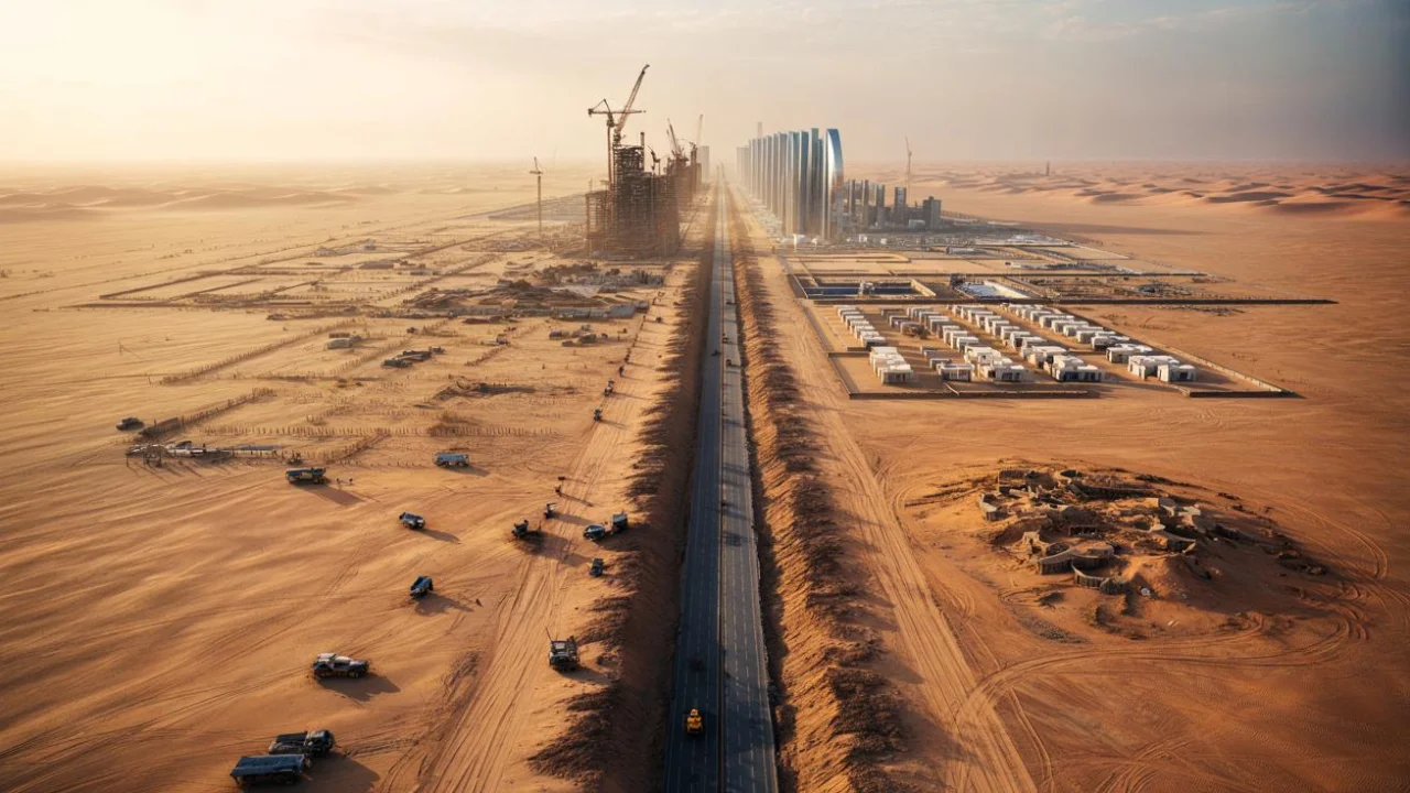
From space, the NEOM megacity looks like surgery on the desert. High-resolution satellite imagery shows a perfectly straight scar stretching across northwestern Saudi Arabia’s landscape, deeper and more dramatic with each passing month. What promotional videos promised as a futuristic paradise appears from above as raw excavation, temporary worker camps, and industrial-scale earth moving.
“When I compare current satellite data to images from just two years ago, the transformation is staggering,” says Dr. Sarah Mitchell, an urban planning researcher who tracks megaprojects via remote sensing. “You’re looking at one of the most intensive construction efforts in human history happening in real-time.”

The scale becomes clear when you zoom out. The Line, NEOM’s flagship project, plans to house 9 million people in a structure 170 kilometers long, 500 meters high, but only 200 meters wide. That’s like cramming the population of New York City into a mirrored corridor you could walk across in two minutes.
Recent satellite passes reveal dozens of active construction zones spread along the planned route. Each shows the same pattern: massive excavation, staging areas filled with equipment, and temporary roads carved into previously untouched terrain. The geometric precision visible from space feels almost violent against the organic curves of desert dunes.

The numbers behind Saudi Arabia’s desert gamble
The NEOM megacity represents more than architectural ambition. It’s a $2 trillion bet on reimagining how humans live, work, and move through space. But the satellite evidence suggests this future may be more exclusive than the promotional materials suggest.
| NEOM Project Element | Planned Scale | Current Status (Satellite Data) |
|---|---|---|
| The Line residential capacity | 9 million residents | Major excavation visible |
| Total length | 170 kilometers | ~40 km showing active construction |
| Construction workforce | Unknown official count | Multiple worker camp complexes visible |
| Land area affected | 26,500 square kilometers | Excavation scars visible across region |
Key aspects emerging from satellite analysis include:

- Massive displacement of sand and rock, creating artificial landscapes
- Concentrated worker housing separated from main construction zones
- Limited integration with existing communities and infrastructure
- Environmental impact visible through changed drainage patterns
- Construction pace varying dramatically across different sections
“The satellite images show something that press releases don’t capture,” explains Dr. James Robertson, who studies Gulf megaprojects. “This isn’t urban development in the traditional sense. It’s the creation of an entirely artificial environment, isolated from everything around it.”
The worker camps visible in satellite imagery tell their own story. These temporary settlements house the thousands of laborers building the NEOM megacity, but they sit firmly outside the planned boundaries of the luxury development itself. The physical separation visible from space raises uncomfortable questions about who this project really serves.
Who pays the price while others live the dream?
The most disturbing aspect of the satellite imagery isn’t what it shows, but what it suggests about social dynamics. The NEOM megacity promises to house millions in luxury, but current evidence points to a development that may be accessible only to the world’s wealthy elite.
Satellite data reveals that existing communities have been largely bypassed or displaced during construction. Traditional Bedouin settlements, visible in older imagery, disappear in recent photos. New access roads connect directly to airports and ports, not to surrounding towns and villages.
Dr. Anna Khalil, who researches Gulf urbanization, puts it bluntly: “Satellite analysis suggests NEOM is being built as a gated community on a massive scale. The infrastructure connects outward to international networks, not inward to local populations.”
The economic reality reinforces this conclusion. With estimated costs of over $200,000 per planned resident, the NEOM megacity appears designed for global elites seeking a climate-controlled desert retreat, not for regional workers or displaced communities.
Environmental costs visible from space add another layer to the inequality equation. Satellite imagery shows dramatic changes to natural water flow patterns and desert ecosystems. Local communities dependent on these resources bear the environmental burden while having little chance of accessing the promised benefits.
“We’re seeing the physical manifestation of economic inequality carved into the landscape,” says Dr. Mitchell. “The people doing the hardest work live in temporary camps outside the project boundaries, while the permanent residents will be those who can afford million-dollar apartments in the sky.”
Ahmed, the former tour guide turned construction worker, captures this contradiction perfectly. He’s helping build a utopian future he’ll never afford to live in, on land where his family has lived for generations. The satellite images simply make this reality impossible to ignore.
The NEOM megacity may indeed represent the future of urban living. But satellite imagery suggests it’s a future designed for a very select few, while everyone else gets to watch from outside the mirrored walls.
FAQs
What exactly is the NEOM megacity project?
NEOM is Saudi Arabia’s $2 trillion futuristic city project in the northwest desert, featuring The Line – a 170-kilometer linear city designed to house 9 million people in a mirrored structure.
What do satellite images actually show about NEOM’s progress?
Current satellite imagery reveals massive excavation work, temporary worker camps, and construction zones, but little resembling the futuristic promotional videos.
How long is The Line supposed to be?
The Line is planned to stretch 170 kilometers across the desert, making it longer than many small countries, but only 200 meters wide.
Who will actually be able to afford living in NEOM?
With estimated costs exceeding $200,000 per resident, NEOM appears designed for wealthy international elites rather than local populations or workers.
What happened to local communities where NEOM is being built?
Satellite imagery shows that traditional settlements have been largely bypassed or displaced, with new infrastructure connecting outward rather than serving local populations.
Is NEOM actually being built or is it just promotional hype?
Satellite evidence confirms massive construction is underway, with dozens of active excavation zones visible, though the pace and final scope remain uncertain.